Sea Level Data
Sea level can be defined as the level of the surface of the ocean, however sea level is always changing. The main cause of sea level change is the astronomical tide, but meteorological conditions (i.e. winds) can also cause important irregular fluctuations.
IHData provides information of these two sea level components, combined and separated: tide and storm surges. To provide the information IHData include three products that provide information about the hourly variation of the sea level components. GOT (Global Ocean Tides) provide information about the astronomical tide, GOS Global Ocean Surges) information about the storm surge and GOST (Global Ocean Surges and tides) information of the sea level that includes the astronomical tides and storm surge.
GOT (Global Ocean Tides) provide information about the astronomical tide,
The astronomical tide is generated using the harmonic constants derived from tide models, we analyse the information of the tide constants provided by different models and choose the best configuration to provide tide level information.
Time series of the tide elevation at any temporal resolution is available in any location worldwide because we use global tide models at different spatial resolution. Our tide information has been validated at global scale and we have developed a methodology that consider the best tide model and configuration for each location.
GOS (Global Ocean Surges) information about the storm surge
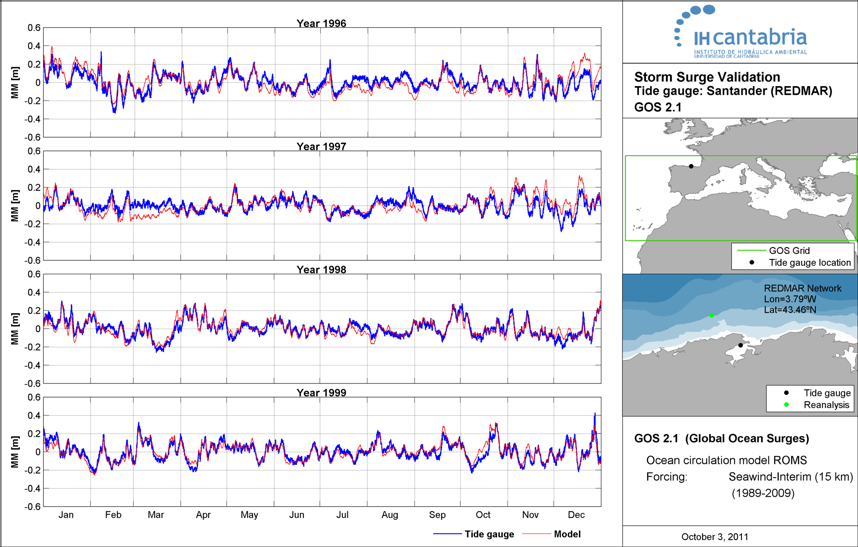
GOS (Global Ocean Surges) is a dataset of storm surge, the storm surge is the sea level variations generated by the wind speed and low air pressures. GOS has been performed using the Regional Ocean Model System (ROMS), developed by Rutgers University. ROMS is a three-dimensional, free-surface, terrain-following ocean model that solves the Reynolds-averaged Navier-Stokes equations using the hydrostatic vertical momentum balance and Boussinesq approximation. The storm surge data has hourly temporal resolution and a spatial resolution that depend on your project zone.
Surge elevations calculated using the ROMS model are validated with measures from tidal gauges and altimetry data. A good agreement between modelled and measured data has be found (figure 4.1), showing the capability of the model to accurately simulate sea level and extreme storm surge events.
GOST (Global Ocean Surges and tides) information of the sea level that includes the astronomical tides and storm surge.
GOST includes the water level forced by the ocean tides and meteorological conditions, the water level include the tides, surges and the non-linear energy transfer between tides and suges that is significant in macrotidal areas. So, the GOST dataset improve the results in macrotidal areas but in microtidal areas the results are similar.
The details about the different historical GOST datasets depend on your project zone, we have available GOST datasets in different zones worldwide although the temporal resolution is hourly.
Tide and surge elevations of the GOST dataset has been validated with measures from tidal gauges and altimetry data, ensuring the quality of the provided data.
Scientific References
Abascal A.J, Castanedo S., Cid A., Medina R. (2012). A high resolution storm surge hindcast in Southern Europe: a useful database for coastal applications. 33rd International Conference on Coastal Engineering (ICCE-2012), COPRI-ASCE, Santander, Spain.
Cid A., Castanedo S., Abascal A.J, Menéndez, M., Medina R. (2014). A high resolution hindcast of the meteorological sea level component for Southern Europe: the GOS dataset. Clim Dyn. DOI 10.1007/s00382-013-2041-0.
CEPAL (2012). Dinámicas, tendencias y variabilidad climática Efectos del Cambio Climático en la Costa de América Latina y el Caribe. Comisión Económica para América Latina y el Caribe (CEPAL) – United Nations (ONU) report, 2012.
Losada, I.J., Reguero B.G., Méndez F.J., Castanedo S., Abascal A.J., Mínguez R. (2013).
Menendez, M., Perez, J., Cid, A., Castanedo, S., Losada, I., Medina, R., & Mendez, F. (2015, April). An European historical reconstruction of sea surface dynamics (waves and storm surge) for coastal impact studies. In EGU General Assembly Conference Abstracts (Vol. 17).